Data Source
Established urban databases
-
Private buildings database
- Source: Home Affairs Department
- Nature: Open data
- Year: 2018
- Number of records: All (40,580) private buildings in Hong Kong
- Data columns: Units, floors, year of built, ownership, geolocation (pending calibration)
-
Registered construction projects
- Source: Buildings Department
- Nature: Open data
- Year: 2005~2016
- Number of records: 144 months
- Data columns: Public information (Contractor, GFA, unit, floors, duration, location, etc.) of new / retrofitted / demolished construction project
-
Real estate deals (residential)
- Source: Land Registry, 28hse.com
- Nature: Mixed (Open and Proprietary) data
- Year: 1996~2018
- Number of records: All (2,062,874) deals in Hong Kong, Kowloon, New Territories
- Data columns: Public information (Date, estate, block, price, area, unit price, location, holding time, price gain/loss, contract type, etc.) of deals
-
Demographics
- Source: Census and Statistics Department
- Nature: Open data
- Year: 2016
- Number of records: All districts (e.g., Central & Western) and subdivisions (e.g., Water Street, Sai Ying Pun) in Hong Kong
- Data column: Age, sex, age distribution from 0 to 85+, education, income, ethnicity, religion, etc.
-
iB1000 digital map
- Source: Lands Department
- Nature: Proprietary (purchased by Faculty of Architecture)
- Year: 2016
- Number of records: 1020 tiles of urban areas
- Data column: 2.5D Geometry
-
Aerial LiDAR scan
- Source: Civil Engineering and Development Department
- Nature: Proprietary (on request)
- Year: 2010~2011
- Number of records: About 1800 buildings in 4km2 around HKU
- Data column: Roof, vegetation, albedo, classification
-
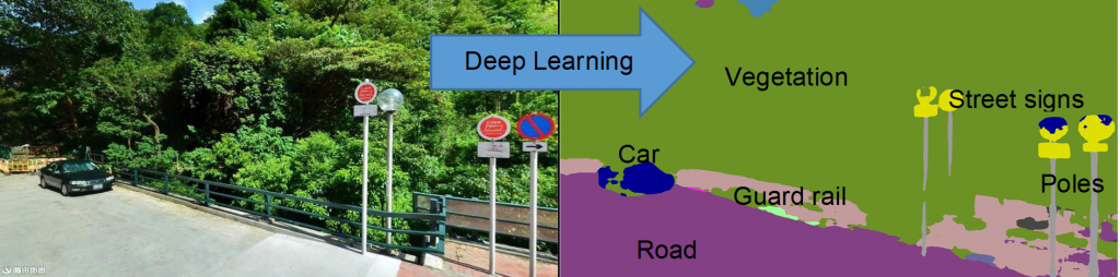
Panorama street view photos
- Source: Tencent
- Nature: Proprietary (by the partnership)
- Year: 2014~2016
- Number of records: ~3,000,000 photos (Every 5~10 meter on any road)
- Data column: Eye-level photos, semantic segmentation
More databases like Hong Kong transportation capacity evolution (2003~2018) and the pollution dataset are pending investigation.
Data Use
We welcome colleagues at HKU to request and use the above data. The original databases of the open data will be available on any request within HKU; the use of the uniform UDBP or other databases requires a formal agreement of collaboration.
UBDP Data Integration
The above databases are being integrated into one uniform urban data set for UBDP by two types of processing:
i. Data Fusion
The data entries in the established databases are being connected to each other via their identifiers and geolocations.
ii. Data Creation
The UBDP also creates new data and 3D models, e.g., street object recognition (see below) and a semantic 3D city model (in progress).
UBDP Architecture
Development in progress
UBDP API
Development in progress