Infrastructure for post-traumatic territories- NEW ‘EXODUS’
|
Infrastructure for post-traumatic territories NEW ‘EXODUS’ Cyprus Greenline UN Buffer Zone Nicosia, View from a bistro towards the ruin inside the Buffer Zone, 2013, by Author Contrasting scene of joyful lifestyle and the war zone forming unique urban condition
Keyword:: wall, enclave, abandon, ruin, contested territories, war, military, re-habitation, boundary, border, divided, infrastructure, exodus, voluntary prison, involuntary park
Prologue Wall is a primary element that forms the space of architecture: it provides people with a sense of enclosure; it differentiates the inside and the outside; and it can be constructed similarly as a partition for a small room or as an infrastructure for urban wall of which their social ideologies can be strikingly different. In a room, the wall forms an enclosed, sheltered dimension for safe and comfortable human stability. In the contrary, in the urban wall like the Berlin Wall, it is community segregation that is perceived painfully. Such polysemous meanings–positivity, negativity–of wall appeared in various scales are alluring to us–architects.
Hypothesis In 1972, Rem’s ‘Exodus’ turned central London into a walled paradise for people to enter voluntarily for the ideal living, an illustration of how the sense of wall as an urban infrastructure can be swung from the unwanted negative aspects to the desirable side of the pendulum.
‘Division, isolation, inequality, aggression, destruction, all the negative aspects of the Wall, could be the ingredients of a new phenomenon: architectural warfare against undesirable conditions, in this case London. This would be an immodest architecture committed not to timid improvements but to the provision of totally desirable alternatives’ Rem Koolhaas, 1972 Shortly after the Exodus, a new urban wall was constructed in the Mediterranean Island–Cyprus, the Greenline, known as UN Buffer Zone in 1974. It divided the island into two halves till now, including the last divided capital in the world–Nicosia. This urban wall segregates two communities from conflict for 39 years: Greek and Turkish Cypriot, Orthodox and Muslim, South and North. Started from 2004, the crossing of the Greenline became possible between the Greek and Turkish Cypriots as Cyprus joined the European Union, though the vote for unification was eventually unsuccessful. Moreover, UN Secretary General Ban Ki-Moon reported in 2011 that “preliminary internal discussions about the UN presence in Cyprus had been initiated” and hinted that “UNFICYP’s continued presence on the island could not be taken for granted”. It provokes what the possible future of this enclave could be.
Cyprus Greenline Site analysis
Thesis Statement The UN Buffer Zone is an enclave of 180 kilometres in length, and from a wall thick to a several kilometres in width. It is a diverse landscape encompassing many type of terrain ranging from the mountain at western side to the flat land at middle and eastern side. It includes the geography of the city centre, village, abandoned airport, farmland, reservoir, archaeological site, and copper mine and arable land. It divides the whole Cyprus into two parts from the west to the east bank connecting the British Sovereign Base as well as the abandoned ghost city Famagusta. It occupies totally 346 square kilometres area which is the 8 per cent of the whole country–including the world’s last divided capital Nicosia. Although it is called no man’s land, actually more than 10, 000 peoples have been living inside the zone since the division and various part of the zone are reclaiming by nature as a new involuntary park[1] . The control for both traffic and pedestrian crossing in the buffer zone was very limited in the past. Not until 2003 were the number of crossings and the rules and tension relaxed.
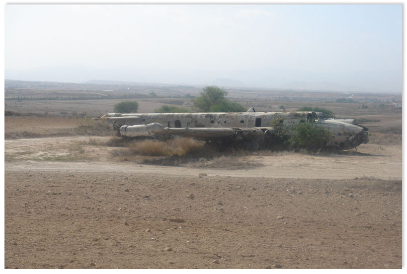
The abandon capital airport within Greenline Nicosia
The thesis takes the buffer zone metaphorically as the wall of an urban infrastructure in Exodus, with the relaxing post-contested socio-political situation, to explore its positive future within the enclave. The possible conjectures could be either reunification or autonomy; nature or artificiality; material or culture; macro or micro; and infrastructure or architecture.
Methodology The research will be a mixture of reality and speculated narrative scenario. The buffer zone is seen as one domain which is started firstly by research investigation, secondly territorial strategy, thirdly developing the urban scenario and finally the architectural proposition. It may be developed as a combination of temporal or permanent; fixed or portable; stand-alone or parasitic forms.
1. Research Investigation- (Dec-Early Jan) The research will analyse the historical, geographical, social, political, cultural, environmental and economical aspects of Cyprus and the buffer zone. The urban and architectural precedents will also be studied. Tentative Outcomes: a. Research conclusion b. Sets of diagrams showing the data c. Resources map d. Manifesto
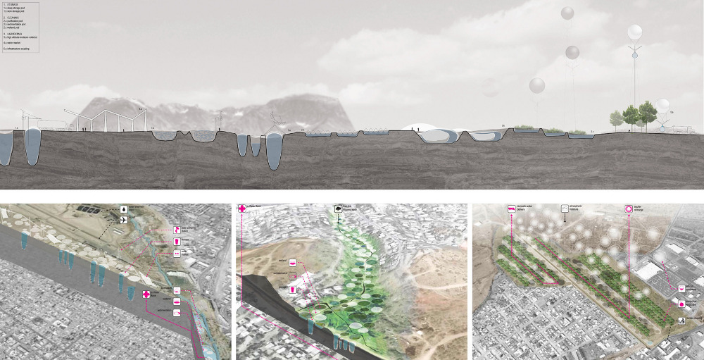
Deadsea Masterplan by Grossmax & Territorial Strategy Model AALU
2. Territorial Strategy 1:150000-25000– (Early Jan-mid Feb) The resultant conclusion from research stage will be used to structure the narrative for the imagined territorial strategy in a proposed period of time. Tentative Outcomes: a. Territorial strategy map b. Diagrammatic strategy model (showing the entire buffer zone 1:150000, & major components and strategy 1:25000) c. Conceptual Image
3. Urban Scenario & Site Selection 1:2500-500– (mid Feb- early March) Based on the territorial strategy, one major site within the buffer zone will be selected to develop the time-based urban scenario in detail. Tentative Outcomes: a. Sets of urban analytical diagrams showing the time-based urban scenario b. Urban scenario map 1:2500 c. Urban model 1:5000 d. 3D image of the Urban Massing
Jordan Deadsea Masterplan development by Metropolitan Workshop UK
4. Architecture Proposition 1:500-50– (early March to mid-May) The architectural scale will be zoomed in and the architectural system will be developed. a. Sets of spatial diagrams showing the architectural system b. Plan elevation section c. Axonometric drawing d. Finalized 3D image of interior, architecture and urban e. Architecture Model 1:2500 1:50
Bibliography
[1] Involuntary park is a neologism coined by science fiction author and environmentalist Bruce Sterling to describe previously inhabited areas that for environmental, economic or political reasons have, in Sterling’s words, “lost their value for technological instrumentalism” and been allowed to return to an overgrown, feral state. |





One Comment
Leave a Reply
You must be logged in to post a comment.
well written and clear. good ! I hope you rethink the “wall” proposal with your upcoming research. The two parts have major differences. Socio economical, political, religious and cultural differences, and not only that they share a history of conflict. Not comparable with HK-Shenzhen, West and East Berlin. This conflict is comparable with Israel, and the Palestinian and Jewish conflict. Within HK-Shenzhen and the former West and East Berlin, an exodus zone – a programed wall -, or special zone scenario would have been understandable, but in this case, I feel you need to dig deeper till you find an answer. You might look into the design research of Eyal Weizman, or Philip Misselwitz and the research around the Gaza Strip etc. for example : http://www.decolonizing.ps/site/